
ARGOLIS
An autumn long weekend in north-eastern Peloponnese
(Oct.2019)
Prologue-Argolis
I left Athens on a Friday afternoon for an autumn long weekend escape. Makis and Glenn were eager to follow. It was a decision I got without much thought as I have some very hard time at work these last months.
Our destination: Old Epidavros (Palaia Epidavros-Παλαιά Επίδαυρος), a little coastal town some 130 km away from Athens on the Peloponnese (on the Saronic gulf, just opposite Agistri island). Βased in Old Epidavros we'd explore some of the very rich history of Argolis (Αργολίδα) Prefecture.
Argolis is scattered with picturesque towns and numerous archeological sites. Lots of Greek mythology has its origin here and the place is full of history going back to prehistoric times.
Nafplion (Νάυπλιο) is the center of Argolis and probably the most beautiful city in Greece. Argolis also prides itself for the ancient Epidavros Theatre, located in its heart and known worldwide as one of the best preserved ancient theaters still in use today. All great actors dream to perform here at a theater placed in the middle of an all green hilly area: the finest landscape mediterranean has to offer.
Mycenean civilization thrived here some 3500 years ago and mythological heroes like Hercules and Theseus "left their footprints" on this land.

Automn leaves.

Argolis perfecture on the map.
Argolis, is known for its huge production of oranges and its old olive tree groves.
Argolis is Greece at its best.

Olive groves, typical of the Argolis countryside.
Note: One cannot explore this area in just one weekend. The area is rather small in size, but there are so much to see and do. For example, intentionally, I left out of this trip two of the most important sites: Mycenae and Epidavros Theater.
This page is just the beginning of me giving you some information and ideas about this lavish part of my Country. Certainly, this page will be revisited many times and new info will be added.
FRIDAY afternoon

From Athens to Old Epidavros is about 2 hours non-stop drive
The best way to go to Palaia Epidavros is to drive for the first 80 Km on the highway (E94) as far as the Corinth canal (Ισθμός) and then, just before crossing the canal, to get off the main road by turning right at exit 9 (towards Loutraki). This way one has the opportunity to cross the old bridge over the canal which is spectacular. The rest of the journey is 60 km on a scenic road (N10), among pine trees and green slopes.
. The red line shows the road one has to follow after exiting the highway to visit the Isthmos bridge and then")
The eastern part of the Corinth canal (Isthmia). The red line shows the road one has to follow after exiting the highway to visit the Isthmos bridge and then "Sea & Sand" restaurant. Blue line shows the road to be followed towards Old Epidavros.
Isthmia

The Corinth Canal.
Of course, like all tourists do, we also stopped for the oblate picture on the bridge over Corinth Canal.
The Corinth Canal connects the Gulf of Corinth with the Saronic Gulf in the Aegean Sea. It cuts through the narrow Isthmus of Corinth and separates the Peloponnese from the Greek mainland. The builders dug the canal through the Isthmus at sea level: no locks are employed. It is 6.4 kilometers in length and only 21.4 meters wide at its base. The canal was initially proposed in classical times and a failed effort was made to build it in the 1st century AD. Construction started in 1881 but was hampered by geological and financial problems that bankrupted the original builders. It was completed in 1893 but, due to the canal's narrowness, navigational problems and periodic closures to repair landslides from its steep walls, it failed to attract the level of traffic expected by its operators. It is now used mainly for small boat traffic.
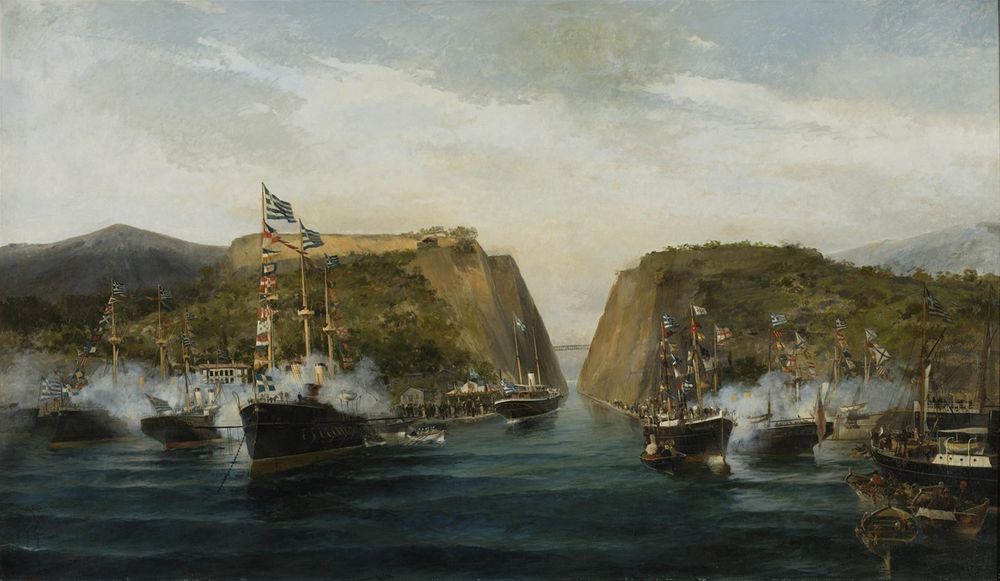
"The Inauguration of the Corinth Canal" (1893), oil on canvas by Konstantinos Volanakis
In the past we used to stop for fried bluntsnouted mullet ("koutsoumoures") at a very nice taverna situated by the waters, just where the sinking bridge is. Unfortunately, it is closed now for some years.
Not knowing where to eat, Ι just looked on google maps and I saw a place called “Sea and Sand café”.
Αlthough late in season, the weather was very good (23οС and a very bright sun). We had some fried calamari, fillet mignon, small fried fish, cretan salad (dakos) and octopus salad for lunch. The tables of the café are set just at the edge of an organized beach. I suppose in summer it gets very crowded, but one can combine swimming and lunch here.

Dinner at Sea & Sand cafe, Isthmia
Moni Agnountos.
On the way from Isthmia to Palaia Epidavros (some 7 kilometres from it), stands the Monastery (moni) of Agnountos, a small but beautiful monument of Byzantine Art and local architecture, which evokes admiration to its visitors and its researchers.
.")
Agnountos monastery on N10 national road (from Isthmia to Palaia Epidavros).
Built on the slope of a mountain, the monastery greets visitors among beautiful olive groves, rocky hills and mountains covered with wild vegetation.
What really is of great admiration, is how neat and tranquil this place is. The moment you enter its gates you emerge to an almost heavenly world. A small garden full of flowers welcomes you.
Although there is no evidence for its construction date, some graffiti made by monks have been found, dating back to 1029 AD.
There is a souvenir shop at the premises, just after the main gate, and a good-natured nun always happy to show you around and to remind you that it is not allowed to take pictures inside the beautifully painted church! Ι Never understand this kind of restrictions...
Old Epidavros

Agnountos Monastery.
The village of Old Epidavros-Παλαιά Επίδαυρος (or Ancient Epidavros, as it also known) is a small fishing village situated in a well-protected small bay.

Old Epidavros village and surounding area.
")
The village of Old Epidavros seen from the main road (N10)
Today, the village serves mainly as the gateway to the Epidavros Theater and as home of the Little Theater of Old Epidavros. During summer months, boats bring ashore tourists who literally swarm the place.
Lots of small hotels, restaurants and cafes cater for the tourists who come to see the numerous archeological sites of the area or to watch a performance at the very prestigious Epidavros Theater.
Less than one kilometer south of the village (where the beaches are), and just some meters from the shore, visitors have the opportunity to admire some underwater classical era ruins. This is the Sunken City of Epidavros.

Old Epidavros village
The most significant place of interest in Old Epidavros is the Little Theater. It is about 1,2 kilometers walking distance at the foothills of the Acropolis of old Epidavros, located just to the south of the village center, amongst orange orchids and olive trees.

The Little Theater of Epidavros located on the map.
The theater used mainly for the events of the Dionysian cult, so it was dedicated to the god Dionysus. From the dedicatory inscriptions, it can be concluded that the construction of the theatre was held during the 4th BC century, with the sponsorship of prominent rulers and upper-class people.
A remarkable characteristic of the theatre is the inscriptions, which consist a real living-museum. This is why the theater is called “the theater that speaks”.

The Little Theater of Old Epidavros.
After 23 centuries of silence, the excavations began in 1971. Today, the small theater is beautifully restored and every July, significant musical and theatrical events take place in it: the most important of all is the program “Musical July”.
In the area in front of and around the theater, the excavations continue bringing into the daylight significant secrets of the local life in the ancient times.
SATURDAY
On Saturday morning, after a long, good sleep and a fulfilling breakfast, we decided to visit the town of Kranidi and to have coffee at the seaside towns of Ermioni and Porto Cheli. The 50km-long road is of good quality, but with many turns.
 From Old Epidavros to Porto Cheli")
(morning tour) From Old Epidavros to Porto Cheli
👍 On our way to Porto Cheli, we did two detours from the main road. The first one was to visit the Didima Caves, located outside the village of Didima; and the second to visit the Franchthi Cave further south.
A third interesting detour is possible if you have the time: to the Monastery of Avgo (Agios Dimitrios). I didn't visit this monastery this time, but in February of 2019, as a special day trip from Nafplion. You can read about this following the link: Nafplion

The detour to visit the Didima Caves. The red line shows the main road and the yellow line the detour.
Didima Caves.
On our way to Porto Cheli, and about 15km (15min) after passing by the village of Trachia (Τραχεία) look for a sharp turn right and a road sign towards the village of Didima (Δίδυμα). Drive on this road (do not turn left towards the center of the village) and look on your right for two road signs: the first says "Didima Caves" and the second (located after 2-3 meters) says "Big Cave, Small Cave". Greek sign posting always amazes me: you either see no signs at all or they come in two!

The entrance to the "little cave" is nothing but a hole on the ground.
The Didima caves are not really caves, in the usual meaning, but two geological formations in the shape of a crater. Mikri and Megali Spilia (Little & Big Cave), also known as Dolines, are of impressive size and about the same diameter, possibly formed by the settlement of the soil.
The Big Cave is located 500m north of the Little Cave and besides being an impressive formation, has no further interest for the visitor.

The chapel of Agios Georgios, inside the Little Cave of Didima caves.
Turn right here at a dirty road in an olive tree orchard. Drive carefully for 500m and you will not miss the "little cave" and its entrance. There is a metal fence surrounding a hole in the ground and a door on it. The door key is on the lock. Open the door and proceed into the staircase-hole-tunnel which leads down inside the cave. The tunnel is narrow and wet, so mind the slippery steps.

The entrance-tunnel to the Little cave.

The big cave at the edge of a beautiful olive orchard.

The chapel of the "Transfiguration of the Savior".
The little Cave is a hollow that hovers to the surface of the ground, the depth of which is 80 m and its diameter 150m. In the inner vertical red-colored walls of the barrow, where one descends through the narrow staircase-tunnel, are located two small chapels: the bigger one, Agios Georgios to the south (of the 13th century) and the smaller one, Transfiguration of the Savior to the north (of the post-Byzantine period).

The interior of the chapel of Agios Georgios.

The fauna of the cave! The interior of the Transfiguration chapel. The exterior of the Agios Georgios chapel.
Franchthi Cave
On our way to Porto Cheli, just after Fourni (Φούρνοι) village there is a gas station. Oposite the gas station, on the right, there is a sign (one of those with yellow letters on brown background) showing the direction to the "Prehistoric cave of Franchthi”. It is worth taking this detour, which is not more than 10 kilometers long (5km to and 5km back).
 cave. The red line shows the main road to Porto Cheli. The yellow line shows the detour to vist the cave, and the green line shows the part of the path that has to be done on foot.")
The detour to visit Franchthi (Frahthi) cave. The red line shows the main road to Porto Cheli. The yellow line shows the detour to vist the cave, and the green line shows the part of the path that has to be done on foot.
After some driving on a not so good road, we arrived at a beautiful deserted beach (Lakkes Beach) with small pebbles, sand and armyrikia (salt cedar) growing just two meters away from the water. South of this beach, on a rock, is located the small white-washed church of Aghios Ioannis, an excellent place for a pick nick.
Just opposite the church and across the bay, one can see the Koilada village and the private island of Koronida (it belongs to the Livanos shipowners family).

The small white-washed church of Aghios Ioannis.

The Franchthi Cave.
Coming down from the little church to the south, one finds himself at another long sandy beach (Lambagianna, Fournoi Beach). At the other end of the beach starts a path (500m long) to another small beach. Above this pebbled beach stands a cave at the base of a rocky hill. There is no way to miss it.
. Koronida island (bottom).")
Map of the small Kilada bay, the prehistoric cave and the private island of Koronida (top). Koronida island (bottom).
This is Franchthi Cave, which was occupied from the Upper Paleolithic circa 38,000 BC through the Mesolithic and Neolithic periods, with occasional short episodes of apparent abandonment. The cave last occupied around 3,000 BC (Final Neolithic). Franchthi cave, is one of the very few settlements in the world that shows nearly continuous human occupation for such an extended period of time, and is one of the most thoroughly studied sites from the stone age in southeastern Europe. The excavations at Franchthi Cave began in 1967 and lasted for a decade.
 and Fournoi beach, where the sign to Franchthi Cave can be seen (bottom).")
The Lakkes beach (top) and Fournoi beach, where the sign to Franchthi Cave can be seen (bottom).
Kranidi
Kranidi (Κρανίδι) is located some kilometeres south of the cave at the edge of the eastermost finger of the Peloponnese peninsula.
The town has a significant nautical tradition and has preserved much of its old character. Even though Kranidi has some interesting churches and old mansions to boast for, it is mainly known as the gateway of the two seaside towns of Porto Cheli and Ermioni, both of them at a distance less than 6 kilometers from it. The greater area of Kranidi is the location of second homes of several prominent celebrities, including Sean Connery and the Dutch royal couple (king Willem-Alexander and queen Máxima).
Porto Cheli

Porto Cheli and its celebrities!
Nafplion

The town of Kranidi.
Porto Cheli (Πόρτο Χέλι) is a summer resort town situated on a bay of the Argolic Gulf, 6 km south of Kranidi. The island of Spetses is located 6 km south of Porto Cheli. There are ferry connections from Porto Cheli to the islands of Spetses, Hydra and Poros, and to Ermioni and Piraeus.
The village is mainly known for the mansions of rich and famous. Ex-King Constantine II of Greece lives here with his wife.
There are lots of cafés by the sea to enjoy your coffee and also to watch people passing by. At the southern most point of the café-row there is a new, but nice, all-white church. We talked about its ongoing restoration (the first after 1975, when the church was built) with the priest of the church, a good looking young man.
While in Porto Cheli, do not forget to pop in to Drougas Bakery for some delicious and fresh sandwiches and cakes.
It was still early, so we decided instead of going back to our hotel, to visit the city of Nafplion (eventhough, that was quite off our route) and have late lunch there.
Much more about Nafplion and the areas around it you will find in my February 2019 page, by following this link: Nafplion
When we arrived in Nafplion (Ναύπλιο) in the late afternoon, the sky was already grey and rain was due any moment.
The place was so crowded and you had the feeling that the whole population of Athens had the same idea with us: to have lunch and coffee in Nafplion. Actually, we met there my friend Myrto with her friends who have visited only for the that evening.
It took us long to find a parking place, but, eventually we parked in the very heart of the city. We call it «κωλοφαρδία»! (When I visited the city, in February 2019, I realised that these parking spaces are reserved for locals only...oh well I did not get a ticket!)

Rainy evening in Nafplion.

The historic center of Nafplion
After parking, we went directly for lunch. The restaurants which are located (one next to the other) on Boumpoulinas street (that is the wide street along the port) have all good food, more or less of the same quality. We chose to sit at «Veto Taverna» (ταβέρνα Βέτο), because its outside dinning area was well protected from the wind and the rain that just started to fall.
We had aubergines (eggplant) in tomato sauce and garlic, fried calamari, veal in tomato sauce (exactly the way my mother used to cook it for me), fried cheese (saganaki), greek salad and meatballs stuffed with feta cheese and Chios mastic (masticha).
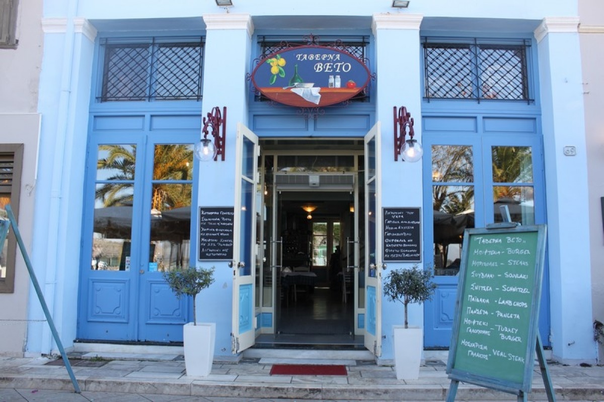
"Veto" taverna
And of course, we had lots and lots of Fix beer to drink.

Our lunch at Veto Taverna.

3Sixty Grill and Wine Bar.
After lunch, we walked a little bit, but as it was raining, we went for coffee and dessert at «3Sixty Grill and Wine Bar». 3Sixty is a new addition to the culinary scene of the city. It is a café, a wine bar, and a grill-restaurant located on the ground floor of a neoclassical building of 1890 in the historical city center. It has a very posh metropolitan ambience: certainly, the hot spot of the town. The second floor of the building houses a luxury boutique hotel.
We just had coffee and some dessert, which I have to say was rather disappointing: ice-cream sealed inside a big chocolate ball, which melts when you pour hot chocolate on it! I had the same some weeks ago in Tbilisi, Georgia. Obviously, it is a very fashionable dessert these days. But this one was too sweet for my taste, the texture of the hot chocolate was not smooth and had an aftertaste of cheap, low cocoa content chocolate.
During our February 2019 stay in Nafplion, we visited the grill-restaurant of 3Sixty for dinner. We had the meatballs as a starter, which were yummy yummy! As main dish we had the slow-cooked beef in tomato sauce with aubergine purée as a side dish and the black pork steak with potato purée. Both dishes were beautiful. For dessert, I had the chocolate/noisette mousse with a touch of lemon cream. It was OK... I was not over enthusiastic. Maybe I am very difficult to be satisfied when it comes to desserts!
3Sixty is not cheap restaurant, but the food is really nice and the atmosphere very elegant and inviting.
By the time we finished our coffee, the rain stopped and we had the opportunity to walk around the narrow beautifully lit streets and do some window shopping.
Nafplion has changed a lot in the last five years: it is more upscale today than it used to be, in the sense of the increased quality of shops and restaurants that open here and there, far from the traditional old greek taverna and the traditional “Kafeneion” (coffee house).
Most of the roads in the the old city have been paved with stones and most of the houses have been renovated. When, I visited in February 2019, almost every second building was under some kind of referbishment.

Dinner at 3Sixty restaurant.

Nafplion after the rain

Nafplion after the rain.

Nafplion after the rain.
SUNDAY
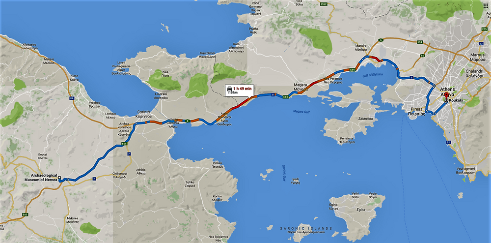
On Sunday morning, we decided to visit Argos and Nemea, before heading back home in Athens.
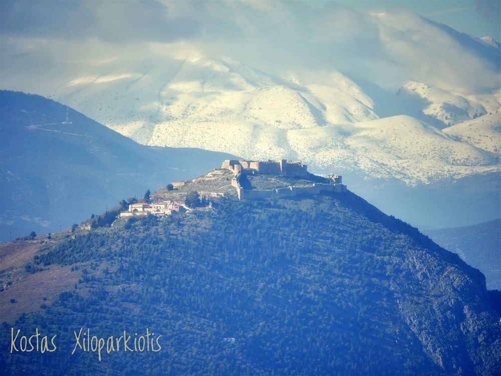
Note: The head picture at the beginning of this chapter is the castle of Argos (Larisa) seen from the Nafplion waterfront (I used a big zoom lenses of course).

Sunday’s itinerary.
"Leonidas taverna", Ligourio

Taverna Leonidas at Ligourio
Mycenean bridges
Very close to Epidavros Theater, at Ligourio (Λιγουριό) village, there is probably the most famous taverna in Greece.
“Leonidas” (Λεωνίδας), is not just the theater men’s taverna, it is a legent. During the summer months, all actors performing at the Epidavros Theater, as well as all visitors attending the performances stay overnight at Ligourio and they all dine at "Leonidas" (or at least they try to).
Leonidas, the owner, was the psyche of the place. He died some months ago, but his family continues the tradition of many decades of feeding traditional greek food to the theater lovers.
The place inside is full of pictures of Leonidas taken together with famous actors, producers and directors.
Argolis is full of Mycenean monuments, as the area was the heart of the Mycenean civilization. Among others, there are at least five Mycenean bridges scattered all over the place. On the road from Epidavros to Nafplion, there are two of these bridges one can visit easily.
 and finishes at Arkadiko village. (II) -Galousi Bridge. (III)-Kazarma Bridge. (IV)- the location of the Arkadikon Bridge, of which only some stones have survived.")
The red line shows the Mycenean Route, a ttrekking trail through history. The route starts on N70 road (I) and finishes at Arkadiko village. (II) -Galousi Bridge. (III)-Kazarma Bridge. (IV)- the location of the Arkadikon Bridge, of which only some stones have survived.

Kazarma bridge.
This bridge is considered as the oldest preserved bridge in Europe and the oldest single-arch bridge still in use today. The bridge was built by the Mycenaeans in the 13th or 14th century BC and was part of the road network. The bridge is made of giant boulders, characteristic of Mycenaean cyclopean structures. Its length is 22 meters, its width 5.6 meters and its height 4 meters.
❤ The first of these two bridges is called the Arkadiko Bridge, better known as bridge of Kazarma (because the Kazarma fort is near by) or MB-A, and it is located on Asklipiou Avenue (near Arkadiko village). Asklipiou avenue is the local road that connects two points of the main road N70 and passes through Ligourio and Arkadiko villages.
The bridge can be easily visited at a road bend just one kilometer before Asklipiou avenue meets N70.

Me standing in front of Kazarma bridge.
Note: The story says that when the single European currency introduced (euro) and they had to design the paper notes (which are common throughout the Eurozone), they decided on one side of them to depict European bridges (as a symbol of the European integrity... you see EU was supposed to build bridges among peoples): the one with the lowest value (5euro note) should have the oldest bridge on and as the value of the note increases it should have newer bridges on them. The note with the highest value (500euro note) depicts a modern bridge. As "stupid Franks” do not know much about history (actually they believe European history starts with Charlemagne on the 9th century AD), they put a roman bridge on the 5euro note instead a Mycenean bridge. Let’s hope when they introduce the 1euro note (there are thought about this) they restore the truth.
❤ The second bridge is known as Galousi bridge (or Petrogephyri Bridge or MB-B) located further west on N70.
One has to be alert to be able to see the “Mycenean Bridge” sign on N70 and to cautiously stop on the N70 itself, as there is no dedicated parking area. Get off the car and walk for about 0.5 km up a trail called “Arkadiko-Mycenean Route”.
The trail, which at this part is not clear of vegetation and can hardly be seen, starts from the N70 and finishes at Arkadiko village to the east, some 10km away.
Tiryntha (Tiryns)
We bypassed Nafplion and we stopped at the archeological site of Tiryns (Τίρυνθα). Ancient Tyrins site is visible from the national road (N70) leading from Nafplion to Argos: one does not have to get into the archeological site to see the impressive fortification walls, but certainly it worth the 2 euro entrance fee to admire this unique archeological site.

Galousi-Petrogephyri Mycenean Bridge.

Ancient Tiryns as seen from the N70 road.

The red line shows the entrance to the Archeological site of Ancient Tyrins. The green line shows the road to the Mycenean vaulted tomb of the area.
The entrance to the site is from the north: turn right just after a white two-storey house with red windows and the tall palm trees, and park at the big parking lot. The archeological site has recently renovated and new trails have been installed. Admire the cyclopean walls and the masonry tunnel. From the top of the palace one has a 360 degrees view of the plain covered with orange orchands.
.")
The Great Propylon leads from the lower citadel to the upper one (left). "They say, this is the work of Kyklopes, who built the wall of TIRYNS for Proitos" -Pausanias, 167 (right).
. The best preserved gallery of the citadel is the 1.65m wide south gallery, which cuts through the external wall that is 11m thick in that area; the side openings led to corbelled store rooms which served as cisterns (top right). The palace and the great courtyard of the upper citadel (bottom left). The lower citadel (bottom right).")
Tiryns was a hill fort with occupation ranging back seven thousand years, from before the beginning of the Bronze Age. It reached its height between 1400 and 1200 BC, when it was one of the most important centers of the Mycenaean world. Its most notable features were its palace, its cyclopean tunnels and especially its walls, which gave the city its Homeric epithet of "mighty walled Tiryns".
The city was linked to the myths surrounding Hercules (According to legend, King Eurystheus of Tiryns, ordered the labors of Hercules), with some sources citing it as his birthplace.
The Great Propylon leads from the lower citadel to the upper one (top left). The best preserved gallery of the citadel is the 1.65m wide south gallery, which cuts through the external wall that is 11m thick in that area; the side openings led to corbelled store rooms which served as cisterns (top right). The palace and the great courtyard of the upper citadel (bottom left). The lower citadel (bottom right).
The site went into decline at the end of the Mycenaean period, and was completely deserted by the time Pausanias visited in the 2nd century BC. This site was excavated by Heinrich Schliemann in 1884-1885, and is the subject of ongoing excavations by the German Archaeological Institute at Athens and the University of Heidelberg.

The entrance to the lower citadel from the western side.
Close to the archeological site of Tiryns, there is a very interesting Mycenaean vaulted (tholos) tomb, the Tiryns tomb. The tomb is located inside an orange orchard, in a landscape of exceptional beauty. The first few kilometers of the road are paved, but the last part is a dirty narrow road which leads to the entryway of the tomb. The tomb was excavated in 1913, on the west slope of Profitis Ilias hill, about 1 km east-south from the citadel of Tiryns.

The tomb dromos and entrance.
 which leads to the entryway of the tomb (right). The entry way actually cuts through an orange orchard.")
The dirty narrow road (left) which leads to the entryway of the tomb (right). The entry way actually cuts through an orange orchard.
 of the tomb.")
The tholos (vault) of the tomb.
The two lowest courses are built of large stones, the rest of limestone slabs, like the dromos. On the north side a burial pit was found, lined with undecorated stucco. No Mycenaean pottery at all was found inside the tomb. It is possible that the contents had been removed in Roman times, although the possibility that the tomb was never used cannot be ruled out. In the Roman imperial period the interior was converted into an oil-pressing installation and a marble base is saved since that period in the tomb.
The dromos (entryway) of the tomb, which was constructed after the raising of the beehive vault, is 13 m long and almost 3 m wide. The walls of the dromos are revetted with roughly cut limestone slabs. The entrance portal of the tomb was decorated with wall-paintings of spirals. The lintel is a monolithic slab measuring 3 x 2 x 0.40 m, while the threshold has not survived. The entrance was closed by a double door. The circular tholos is 8.45 – 8.50 m in diameter.

Part of the Roman olive press inside the tomb.

Me outside the Tiryns tomb.
Argos

With Makis, enjoying the sun at the ancient theater of Argos
Argos (Άργος) was one of the most significant cities in ancient Greece. Today, Argos is a rather unpleasant city, but it has a very interesting archeological site and a compact, but important, Archaeological Museum.
We stopped for coffee at the main square of the modern city (Saint Peter’s Square), where the cathedral church and the Archeological Museum stand. There are lots of cafés on the square, but what is really beautiful is the view from the square towards the acropolis of the city: the view of “Larissa Castle” on the top of a high hill and of the “Monastery of Panagia Katakekrymmeni”, located just below the castle, is just stunning.
The archeological site has lots of interesting buildings to enjoy, but the Roman baths and the ancient theater certainly attract visitor’s attention. The ancient theater is one of the very few ones totally carved on the hill rock itself.

The center of Argos and the Archeological site.

The baths and theater at Argos aercheological site. Notice the color match of my T-shirt and the lizard.

“Larissa Castle” on the top of the hill and the “Monastery of Panagia Katakekrymmeni” just below it.
Dervenakia
It was already late in the afternoon and we were hungry. We headed north towards Nemea having in mind to find a nice place for dinner. We passed the Dervenakia pass.
Dervenakia (Δερβενάκια) is a small village on the old national highway from Nafplio to Corinth (N7). The name is derived from the Turkish word “derven”, meaning mountain pass. Actually, there are many villages in Greece called Dervenakia or Dervena.

The "Chani of Anestis" taverna (the summer garden).
The place is famous for the Battle of Dervenakia, fought on 26–28 July 1822 during the Greek War of Independence, where 2,300 Greek irregulars under Theodoros Kolokotronis defeated the 30,000-strong army of Ottoman general Mahmud Dramali Pasha.
One kilometer north of Dervenakia, on the N7, there is one of the best spots of the area for having a meal: “The Chani of Anestis” (Το Χάνι του Ανέστη).
This is an exceptional beauty location of an historical Inn built next to a natural water spring. The vegetation is dense, making the spot a great place to escape from the merciless summer sun.

Dervenakia village and the location of the "Chani of Anestis" taverna. The red line shows the route 7 from Argos to Corinth, while the green line shows the detour to Ancient Nemea.
On that very spot of the old Inn there are two tavernas.
These tavernas are what we used to call “rural family taverna” in the old days of my childhood.
This kind of restaurants are simple tavernas with a limited variety of dishes to offer: actually, they offer only grilled meat.
We’ve chosen the taverna on the right hand, which seems to belong to the same family the old Inn belonged.
Under the dense shade of the trees, accompanied by the sound of running water and by ten kittens and two dogs, we tasted the traditional grilled pork steak-brizola (μπριζόλα), saganaki (σαγανάκι) fried cheese (of course), greek salad (χωριάτικη) and we had some deep red house wine to drink. The area is well known for producing some great wine.

Τhe "Chani of Anestis" taverna.

Traditional taverna food

We finished our beautiful dinner with some greek coffee and "Ypovrychio" (submarine), which is a sweet paste made of Chios masticha and sugar, plunged into water. Another treat of my childhood.
 and in February 2019 (right).")
The tavarna dog in October 2017(left) and in February 2019 (right).
Ancient Nemea
Our next and last stop Ancient Nemea (Νεμέα), an ancient site situated in the regional unit of Corinthia.It is located only some 4-5km away from the taverna we had dinner: continue for one km on route 7 (towards Corinth), turn left on route 66 and continue for 3-4 km to Ancient Nemea. Mind that Ancient Nemea is a different village than Nemea.

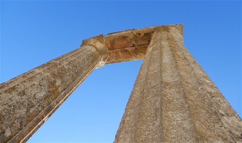
The Temple of Zeus in Nemea.
Here, according to Greek mythology Heracles (Hercules) overcame the Nemean Lion of the Lady Hera, and here during Antiquity the Nemean Games were played, celebrated in the eleven Nemean odes of Pindar.
The archeological site, one of the most beautiful in the area, is located among vineries, which can be visited. The temple of Zeus is dominating the place, while the small but important museum offers to the visitor a complete view of the life in ancient times and an interpretation of the excavations in the area.
Not far away from the temple of Zeus is located the ancient stadium.
.")
Ancient Nemea (village and archeological site).
A bit of Nemean History
The Sanctuary of Zeus at Nemea developed in the beginning of the 6th century BC, with the institution of the Panhellenic Nemean Games. The first temple was constructed during the Archaic period. At the end of the 4th century BC, a new temple of Zeus, baths, a hostel, a Stadium and the Heraion were built as part of a large construction project. After the transfer of the games to Argos, in 270 BC, the sanctuary fell into decline.
The first, small-scale excavations were carried out in 1766 and were continued in 1884-1912 by the French School of Archaeology at Athens. Between 1924 and 1926, investigations on the site were undertaken by the Americal School of Classical Studies. Following a long interruption, C. Williams, brought to light in 1964 some new findings. Extensive and systematic excavations on the site were carried out from 1973 to 1986 by the University of Berkeley at California, under the direction of Stephen G. Miller.
The Stadium of Nemea, which could accommodate 40.000 spectators, was built 400 m SE of the Temple of Zeus. The track (total length of 178m) was bordered by a stone water-channel with stone basins at intervals for drinking water. The stone starting line was on its western extremity. A rectangular building with an internal colonnade on its western side served probably as a "changing room". From it, the athletes and the judges entered the Stadium through a vaulted tunnel. The spectators sat in roughly levelled terraces (degrees), cut in the soft rock, while two or three rows of seats were constructed between the starting-line and the stoas.

The Stadium of Nemea.
The Stadium in which Panhellenic games were held every two years in honour of Opheltes, was built at the end of the 4th century BC, as part of a renovation project of the Sanctuary. In about 270 BC, the games were transferred to Argos.
The modern Nemea Games

The modern Nemea Games logo.
Today, the Modern Nemea Games are organized (called Nemead) every four years. The Society for the Revival of the Nemean Games is a movement born from nearly 40 years of excavations by the University of California at Berkeley in the panhellenic Sanctuary of Zeus at Nemea, Greece, and from the enthusiasm and dedication of local residents of Nemea who feel that they could make an important contribution to today's world because of their personal ties to Nemea.
"It is our belief that the modern Olympic Games, despite their obvious success in many respects, have become increasingly removed from the average person. Our goal is the participation, on the sacred ancient earth of Greece, of anyone and everyone, in games that will revive the spirit of the Olympics. We will achieve this by reliving authentic ancient athletic customs in the ancient stadium of Nemea." (Statement of the Purpose of the Society, December 30, 1994).
Already six Nemeads organized and the seventh one took place on June 26-28, 2020. https://nemeangames.org/
👎 January 2018 update:
The American archaeologist who masterminded the recovery of the ancient site in Nemea says that because of lack of guards, the site is in effect off limits to visitors for much of the year.
I am afraid this is typical of most archeological sites in Greece, which remain closed during winter months (off season), or close early in the afternoons, due to lack of personnel.
Read the full article at:

Rubens was a masterful painter of oil sketches, which he used to generate pictorial ideas and display them to his patrons and workshop assistants. This sketch may relate to a commission he received in 1639 for a series of hunting scenes for the Royal Palace in Madrid. It depicts the first of the twelve labors of Hercules: strangling the lion sent by the goddess Hera to menace the region of Nemea. Hercules donned the impenetrable skin thereafter. In Rome, Rubens had drawn studies of the Farnese Hercules — one of the most famous sculptures of antiquity — and the muscular hero, a human who achieved immortality through his deeds, was a favorite subject. Here Rubens emphasizes the confrontation between man and beast. Aside from some impasto in the lion’s mane and in the torso of Hercules, Rubens painted thinly, leaving visible the ground layer, or imprimatura, whose horizontal streaks enhance the impression of swift movement and action.

The temple of Zeus and the mascot of the archeological site.

The temple of Zeus and the museum of Nemea
epilogue
Nemea, is very close to Corinth. There are lots and lots of interesting and beautiful places to visit around there.... but let's leave it for another weekend.
It is already late and the drive to Athens is more than an hour long (on the highway). I need some rest. GOODNIGHT.

Flowers of the Argolian land